QUAKER HERITAGE TRAIL
91-mile self-guided driving tour of Burlington County, NJ
INTRODUCTION
There are 21 existing Quaker Meeting Houses in Burlington County. Some are active, others are seasonally active, and some have been “laid down” – the Quaker term for abandoning their use as places for Quaker worship. This tour has been created to allow residents to visit all 21 of them. Such a tour will provide insight into the rich history of Burlington County. The tour does not include, nor does it require, visits to the interior of any of these buildings, although certain guided tours which include selected tours of individual facilities are planned for special occasions in the future. The complete 91-mile tour is somewhat aggressive for a single day tour. Mini-tours or two half-day adventures are suggested as alternatives. Sites may be visited in any order. The sequence selected for this tour (starting in Burlington City and ending in Mt. Holly) is based on the historical Quaker significance of these starting and finishing locations. The remaining sequence is a logical succession of sites based on proximity and route accessibility.
Dates which appear immediately after the name and location of the individual site are to be understood in this manner:
- The first date in the sequence represents the establishment of the particular Quaker community. Quakers worshiped in private homes prior to building their Meeting Houses or Schools.
- The last date in the sequence represents the date that the existing structure was constructed.
- Any intermediate dates represent the succession of structures. Early Meeting Houses were built of logs or wood, and many burned down or simply deteriorated, being replaced by bigger and better built structures, the final ones being of brick or stone. In a few cases, the present structure is the third or fourth generation of the Meeting House.
1. Burlington Quaker Meeting – 340 High St., Burlington City
1678; 1687; 1783 – Laid Down – Philadelphia Yearly Meeting Conference Center
To get the full flavor of the total tour, begin at the inland side of the Riverbank, between Talbot and Wood Sts. at the monument commemorating the site of the mooring of the ship “Shield” at a large buttonwood tree on December 10, 1678. The “Shield” of Stockton, England, was the first ship to navigate the Delaware River from the Atlantic Ocean to Burlington, setting the stage for Burlington’s eventual emergence as the third largest port in the New World.
Continue on Riverbank to Wood St. Turn right and proceed to the Quaker Meeting House (dating to 1783) at 340 High St. on the right.
Parking is available in the Municipal lot directly across High St.
Visit the burial ground in the rear, where a bronze plaque on a large stone remembers Chief Ockanickon of the Mantas tribe of the Lenape. You can exit the burial ground by the rear gate and make your way left on Wood St. to W. Broad St. to see the plaque commemorating William Penn’s “Concessions and Agreements” (1676) on the Surveyor General’s Office.
Leave Burlington via E. Union St. (right turn out of Parking Lot), turning left on York St. The 1792 Friend’s School, located on York St. between Penn and East Union.
Continue on York St. turning right on Pearl Street, continuing to Jones St. Turn right on Jones St.; left on Bordentown Road; left onto Route 130 heading north to Bordentown. Follow Route 130 for about 6 miles, turning left onto Route 662, which you follow for less than 2 miles through Fieldsboro and into the City of Bordentown. Turn left on Farnsworth Avenue, proceeding to # 302 on your left, the former Bordentown Quaker Meeting House
Distance between Burlington and Bordentown: 8 miles
2. Bordentown Friends Meeting – 302 Farnsworth Ave., Bordentown
1740; 1813 - Laid Down – Headquarters of Bordentown Historical Society
Recently restored; Note difference in brick color on upper level (roof raised).
Upon leaving, take Crosswicks St. (at fountain/monument immediately across the street) towards Rt. 130. .3 miles on the right on the corner of Crosswicks and E. Burlington St., across from Lafayette St., you will see the historic Clara Barton one-room schoolhouse, once a Quaker School. Proceed on Crosswicks, crossing Route 130/206 at the traffic light, continuing straight ahead for a little less than 2 miles. Prepare to turn left onto Route 672 N immediately after you cross over the NJ Turnpike. Continue on 672 N for about 2 miles, dead-ending at Ward Avenue, Crosswicks. Within view at this intersection, across Ward to the left is the former Orthodox Meeting House. To visit, turn left; to simply view and move to Hicksite Meeting, turn right on Ward Avenue.
Distance between Bordentown and Crosswicks: 4 miles
3. Crosswicks Orthodox Meeting – 530 Ward Avenue, Crosswicks
1831; 1854 – Laid Down – Headquarters of the Chesterfield Township Historical Society.
If you visited the site, backtrack down Ward Avenue – or if you turned right at the end of 672, turn right onto Church St. The active Crosswicks Quaker Meeting is at the end of Church St. at the corner of Front St., on the left.
4. Crosswicks Monthly Meeting – Intersection of Front and Church Streets.
1677; 1693; 1773 – Active Meeting
One of the largest Meeting Houses in South Jersey.
Hessian soldiers used it in June, 1778. Carvings (graffiti) on men’s side; stove cast at Atsion; Member John Taylor of “Taylor’s Pork Roll”; Revolutionary War cannonball in north wall.
Upon leaving, turn right onto Front St.; left on Buttonwood (which becomes Bordentown-Crosswicks Road – Rt. 672). After about 2 miles, turn right onto Route 528, following it to the sign pointing to Route 206 south (left off of Rt. 528). Turning left onto Rt. 206, continue for about 4 miles to immediately after Mile Marker #32 at the traffic light at Mansfield Road East. There are 2 white posts immediately after the light at the driveway entrance to the Meeting House immediately after the light on the right.
Distance between Crosswicks and Mansfield Meeting: 7 miles
5. Mansfield Monthly Meeting – 3191 Route 206 South, Mansfield Township.
1684; 1731; 1812 – Pending reopening
Seasonally operational for special events. Under administration of Crosswicks Friends; new roof recently installed.
Upon leaving, turn right onto Route 206 south. Continue south on Route 206 for a little over a mile, passing by Hedding Road. After Mile Marker #31, prepare to turn right onto Rt. 543 into Columbus (just after the Dog Kennel at the corner). At the end of the off-ramp, turn right onto Route 543. Continue on 543 for a little over half a mile and then turn left onto Petticoat Bridge Road. The large tree on the right just after the turn is the symbol of Mansfield Township. Continue on Petticoat Bridge Road; a little under half a mile you will cross over a non-descript bridge – this is Petticoat Bridge, where a Revolutionary War battle took place on December 23, 1776 (see Historical Marker on south side of the bridge). Continue on and dead-end at the Stop Sign at Rt. 670. Turn right onto Rt. 670 and continue for less than half a mile, and as soon as you cross over a tiny bridge, look to your left – where tucked away behind the trees is Copany Meeting. Find a place to turn around to head back to Rt. 206 via Rt. 670. However, pull over before the driveway to Copany Meeting to see the Historical Marker describing the role of Copany in the Battle of Petticoat Bridge.
Distance between Mansfield Meeting to Copany Meeting: 4 miles
6. Lower Springfield Meeting (Copany) – 1832 Jacksonville-Jobstown Rd., Springfield.
1698; 1775 – Laid down
Private residence; After the Battle of Petticoat Bridge on December 23, 1776, while nearing final completion, it was temporarily used as a hospital for Hessian troops; bloody handprint still visible on ceiling board. Small burial ground behind building. Date 1775 built into upper west wall.
Continue east on Rt. 670 ( Jacksonville-Jobstown Rd.). At WaWa (Rt. 206 traffic light) continue straight across Rt. 206 on Jacksonville-Jobstown Road for about 2 miles through Springfield. You will pass the Springield Township Municipal Building on the left and Middle School on the right, arriving at the traffic light at Monmouth Road (Rt. 537). Turn left at the light onto Monmouth Rd. Less than a mile on your right you will see Meeting House Road at an angle on the right. Turn right onto Meeting House Road, continuing for about 2 miles, arriving at the intersection of Rt. 68 (there’s a ground-level concrete triangle at the intersection). Cross 68, continuing on Meeting House Road, up the hill till it dead-ends at Highland Road. On the left you will see a truncated Meeting House – now a private dwelling. Turn left onto Highland to behind the house where you will see an Historic Marker and a cemetery. You can turn your car around before disembarking at the burial ground.
Distance between Lower Springfield (Copany) to Upper Springfield: 7 miles
7. Upper Springfield Meeting and Burial Ground – corner of Springfield-Meeting House Road and Highland St. , Springfield Township.
1727 (1916 –current restoration of half of original building) – Laid down.
Private residence. One of the earlier meeting houses in the region. Site is at intersection of two Indian Trails. Burial Ground on National and New Jersey Historical Registers. Memorial to Burlington County Revolutionary War casualties in burial ground.
Turn right onto Springfield-Meeting House Road. Cross over Rt. 68 again, continuing on for about a mile. Watch for Juliustown-Springfield Road on the left. Turn left onto Juliustown-Springfield Road. You will stay on this road for about 2 miles, crossing Saylors Pond Road, and arriving at the Stop Sign in Juliustown just after the Huff ‘n Puff farm (on the right). At the Stop sign (there’s a Mobil station on the far right hand corner) turn right onto Main St., which is also called Juliustown Road. About a mile and a half you will arrive at the intersection of Arney’s Mt. Road. The meeting house is on the far left corner. Turn left onto Arney’s Mt. Road, and make a quick right into the meetinghouse parking area.
Distance between Upper Springfield and Arney’s Mount: 6 miles
8. Arney’s Mount Meeting – intersection of Juliustown Road and Pemberton-Arney’s Mount Road, Springfield Twp.
1743; 1775 – Seasonally Active
Under the care of Mt. Holly Monthly Meeting. Selected for major study of historic sites (HABS) because it maintains its architectural integrity – no heat; no water. Built of native NJ Sandstone quarried from the Mount.
Turn left again onto Juliustown Road, heading west towards Route 206 for about 2 miles. At the stop sign, turn left onto Route 206, heading south towards Vincentown. Continue south on Rt. 206, crossing Route 38 at the Vincentown Diner, until almost a mile past Mile Marker 23, where you veer right onto North Main Street (Rt. 681), into Vincentown. You will pass the intersection of Mill St. at the Sovereign Bank, continuing on Main St. to Grange St. on the left. Turn left onto Grange St. and then make an immediate right into the parking lot of the Vincentown Grange, a former Friends Meeting House.
Distance between Arney’s Mount and Vincentown Grange: 8 miles
9. Vincentown Grange – 115 Main Street, Vincentown.
1781; 1813- Laid down in 1912 and sold to the Grange
Vincentown was founded by Quakers and was once called “Quakertown”.
Small burial ground in the rear contains Irick and Eayre tombstones. Use as a Grange Hall for community events is reflective of Southampton’s rich agricultural history.
Turn right onto Main St., continuing to the intersection of Mill St. at the Sovereign Bank. Turn leftt onto Mill St., which becomes Church Road (Route 616) outside the village of Vincentown. You will stay on Church Road for about four-and-a-half miles, passing, on the right, Kirby’s Mill first, and then the Office of Dr. James Still, the Black Doctor of the Pines, before arriving at “Crossroads”, the intersection of Church Road and Route 541 (Mt. Holly-Medford Road – there’s a WaWa Market on the far left corner). Turn left onto Rt. 541 and proceed to the intersection of Route 70. Continue across Rt. 70 into the Village of Medford on North Main St. Continue through the traffic light at Union St. straight ahead onto South Main St. A short distance ahead, at Mile Marker # 10, you will see, on your left, set back in the distance, the former Hicksite Meeting House (at # 53 S. Main St.). Turn left on South St. and then turn into the driveway of the Meeting House.
Distance between Vincentown Grange and Medford Meeting: 6 miles
10. Main Street Friends Meeting House, 53 S. Main St., Medford.
1842 – Laid down
Abandoned for many years and in desperate need of restoration, this former Hicksite Meeting House was recently purchased by the St. Vincent de Paul Society, a Roman Catholic Social Organization, for use as offices.
Continue around driveway and back out to Main St. Turn right and go up to the traffic light at Union St., and turn left onto Union St. Just after the two or three commercial shops on the left, turn into the driveway of the Union St. Friends Meeting House.
11. Medford Monthly Meeting, 14 Union Street, Medford.
1793; 1814 – Active meeting
The rear of this building faces Union St. Old Schoolhouse on the property is used as a private residence. Internal dividing doors manipulated by a series of pulleys.
Upon exiting, turn left on Union Street and continue on Union, which becomes Old Marlton Pike, and proceed through the traffic light at the intersection of Hartford Road, continuing on Old Marlton Pike until, just before reaching Rt. 70, it takes a hard left (onto Rt. 618) and continues into Evesham Township. Travel for about 2 miles when this road dead-ends into Tuckerton Road (Route 620) at Pine Grove Church. Turn right and continue on Rt. 620, on through the intersection at Willow Bend and Evans Roads, where it becomes Main St., Marlton. Continue past the Fire House on Main St. Marlton to the corner of South Maple St. Turn right onto South Maple and take it to the traffic light at the intersection of Route 70. Turn left onto Rt. 70, and go a quarter of the way around the Rt. 70 circle, taking the sharp left onto Rt. 73 south towards Berlin. Shortly after the light, turn right onto Old Marlton Pike behind Olga’s Diner and continue just past South Cropwell Road on your left, and look for the sign and driveway to Cropwell Friends Meeting on your immediate left, just opposite the back entrance to Burns Pontiac.
Distance between Medford Meeting and Cropwell Meeting: 7 miles
12. Cropwell Monthly Meeting, between South and North Cropwell Roads on Old Marlton Pike, Evesham.
1786; 1809 – Active meeting
Just over the border from Camden County, it was approved by the Haddonfield Quarterly Meeting in 1794. It was controlled by the Orthodox after separation. An oasis in one of the most congested commercial and residential sections of Burlington County. Evans, Reeve, Lippincott, Shinn, Haines and Braddock are among early families associated with Cropwell.
Upon leaving the driveway from Cropwell, turn left onto Old Marlton Pike and proceed to the traffic light, turning right onto North Cropwell Road. At Route 70, turn right and continue east on Rt. 70, around the circle, continuing past the circle on Rt. 70 for about 4 miles until you come to the light at North Elmwood St. Turn left onto N. Elmwood and continue for about 3 full miles, going through the traffic signals on Evesboro-Medford Road (618) and Church Road (616) where it becomes Mt. Laurel Road, continuing until you reach the traffic signal at Elbo Lane. Turn right onto Elbo Lane, and immediately on your right you will see Jacob’s Chapel. Turn right into the driveway (or, there is additional parking across the street).
Distance between Cropwell Meeting and Colemantown Meeting (Jacob’s Chapel): 6 miles
13. Colemantown Meeting (Jacob’s Chapel), 318 Elbo Lane, Mt. Laurel, NJ
1813 (Meeting House); 1859 (Jacob’s Chapel)
Elbo Lane was once known as Colemantown Road and was a part of Evesham Township and the village of Colemantown, named for John Coleman, a well respected man of color. Coleman was involved in the Underground Railroad. The federal census of 1830 shows that Evesham had the largest free black population in Burlington County – mainly because it enveloped the Quaker community at Mt. Laurel. The freed slaves worked on Quaker farms. The Quakers of Mt. Laurel were active in the Underground Railroad movement and often thwarted the kidnapping of freed slaves. Jacob’s Chapel is named for a Quaker, Albert Jacobs, who sold the land for $4 to the Black community for the church in 1840. The 1813 Meeting House, originally located across the street, was moved to its present location in 1965, where it serves as the social hall for Jacob’s Chapel. The earlier meeting house was purchased for $1 from an unknown source by three freed slaves and was used as church, school, way station for the Underground Railroad, and a gathering spot for many African Americans who lived in the area. Several Black veterans of the Civil war are buried in the cemetery, along with Dr. James Still, the Black Doctor of the Pines.
Upon leaving this site, backtrack on Elbo Lane to Mt. Laurel Road, turning right onto Mt. Laurel Rd. and proceeding a little less than 2 miles, through the light at Mt. Laurel-Hainesport Road, turning right into the parking area for the Mt. Laurel Meeting at the north-east corner of the intersection.
Distance between Colemantown Meeting and Mount Laurel Meeting: 2 miles
14. Mount Laurel Meeting, corner of Moorestown-Mount Laurel and Mount Laurel-Hainesport Roads
1694; 1717; 1760 (e); 1798 (w)
William Evans and Elizabeth Hanke arrived in Mt. Laurel and lived in a cave on the Mount. The recently restored Farmers Hall is at the foot of the Mount on the north-west corner across from the Friends Meeting House. The Meeting House is constructed of native Jersey sandstone quarried on the Mount. Colonial Militia and British troops (General Clinton – June, 1778) occupied the Meeting House during the Revolutionary War. The largest Sassafras tree in NJ (second largest in America) is on the grounds; Large historic Penn Oak fell 9/3/2000 (stump remains). Unmarked burial ground is located within four white corner markers. During the Hicksite separation, the Quakers “cordially” shared the building, one using the older section and the other, the newer.
Upon departing, return to Mount Laurel-Hainesport Road via Moorestown-Mt. Laurel Road, turning left at the intersection onto Rt. 674 – Mt. Laurel-Hainesport Road. You will continue on this road for a little less than 4 miles, passing through the intersections at Hartford Road, Larchmont Road and Ark Road, until arriving at the 4-way Stop with blinking red traffic signal. This is Fostertown Road. Turn right onto Fostertown, and almost immediately you will see on the left, the Easton Union Church, site of the former Easton Meeting House. Turn left into the parking lot.
Distance between Mount Laurel Meeting and Easton Union Church: 4 miles
15. Easton Meeting House, 2407 Fostertown Road, Hainesport, NJ 08060
1811
The Easton Union Meeting House and cemetery were originally begun in 1811 by the Society of Friends. The meeting house, cemetery and all other land was first sold by the Quakers to the Easton Union Church about 1949-50. Later about 1968 the Easton Bible Church purchased all of it.
Upon leaving the parking lot, turn right onto Fostertown Road, taking it up to the Route 38 intersection. Turn left onto Route 38 and follow it for a little less than 5 miles to the intersection of Mt. Laurel-Moorestown Road. Turn right and proceed to Main St. Moorestown. Turn left at the top of Mt. Laurel Road at the light and continue east on Main St. to the intersection of Chester Avenue. We recommend visiting three areas at this intersection: the open field and burial ground on the north east corner of Chester; the 1802 active meeting opposite the north west corner; and the “1897 West Building” on the grounds of the Friends School – therefore, we suggest parking on the grounds next to the 1802 active Meeting House.
Distance between Easton Union Church and Moorestown: 6 miles
16. Moorestown Monthly Meeting (Hicksite), 118 East Main St., Moorestown
1700; 1720; 1802
The granite stone across the street at the north east corner of Chester commemorates earliest Quaker house of worship – and in fact, the oldest house of worship in Moorestown. In 1778, the British Army under General Clinton camped on the old Meeting House grounds prior to the 1802 construction of the current building.
Proceed across the driveway which leads to the Friends School to the building on the corner of the driveway/entrance and Main St.
17. Moorestown (Orthodox) Meeting, 110 Main St., Moorestown
1839; 1897
Currently used as a cafeteria in the West building of the Moorestown Friends School. When the Hicksites took over the 1802 building in 1827, the Orthodox used the school house for worship. Famous Quakers: Samuel Allen, inventor of “Planet Jr.” (spreader/cultivator); flexible flyer sled; George Abbott, of Abbot’s Dairies and of Pocono Manor fame.
Upon leaving, proceed north on Chester Avenue (603) which will become Riverton Road as you approach Cinnaminson Township. Continue on Riverton Road towards Rt. 130, proceeding past Bridgeboro Rd. and New Albany Road. A short distance past the Cinnaminson Middle School (on your left) you will arrive at the Westfield Friends complex – first the Friends School, then the 1963 Meeting House and the 1859 former Meeting House (now a pre-school). Turn left into this driveway.
Distance between Moorestown and Westfield Meeting ( Cinnaminson): 5 miles
18. Westfield Monthly Meeting, 2201 Riverton Road, Cinnaminson
1788; 1794; 1800; 1859; 1963
Abraham Warrington’s School established in 1788 has been preserved as the office of the school Headmaster. Some of the trees on the property were planted in 1861 at time of firing on Ft. Sumpter. Alice Paul, women’s suffragist, herself a Quaker from Mount Laurel, is buried in the cemetery.
Upon leaving, proceed to Route 130 by making a left out of the parking lot and then a quick right onto the ramp to Route 130 north. You will travel about 6 miles north on Route 130, arriving at the right hand jug handle to Charleston Road/Cooper St. (Landmarks in view at the intersection are a Sunoco and LukOil service stations, Walgreen’s Drug Store and BNM Auto, behind which is the Coopertown Meeting). At the end of the ramp, turn left on Charleston Road and proceed to the light on Rt. 130. Cross Rt. 130, where Charleston Road now becomes Cooper St., Edgewater Park. On the right, behind BNM Auto is the Coopertown Meeting and Cemetery.
Distance between Westfield Meeting (Cinnaminson) and Coopertown Meeting ( Edgewater Park): 6 miles
19. Coopertown Meeting, Cooper Street, just west of US Highway 130, Edgewater Park
1802; 1806
Not exclusively for Quakers. According to their constitution: “That any sect or creed should have the right to worship there, provided they believed in the Divinity of Jesus Christ and should be forever free”…During 1901, the Society of Friends used the building for worship and contributed a sum to erect the horse shed. The building is maintained by The Riverfront Historical Society, which had created a museum highlighting the history of the Riverfront communities of Beverly City, Delanco and Edgewater Park.
Upon leaving via the driveway in front of the Meeting House, turn left onto Cooper St., and cross over Route 130, proceeding on Charleston Road until it intersects Levitt Parkway, a distance of a little over a mile. Turn right on Levitt Parkway, continuing east for about two-and-a-half miles to Springside Road. Turn right onto Sprinside Road, proceeding less than a mile to a right turn onto Valley Farm Road. Turn right at the Stop Sign onto Main St., Rancocas. Continue to the Rancocas Friends Meeting on the right, adjacent to the Rancocas Community Center (a converted Fire House).
Distance between Coopertown Meeting and Rancocas Meeting: 5 miles
20. Rancocas Monthly Meeting, 201 Main St., Rancocas
1681; 1703; 1772
The father and grandfather of John Woolman worshiped here, as did Thomas Olive, the first speaker of the NJ Assembly and Governor – and founder of Willingboro. This was actually the second Friends Meeting established in Burlington County (after the Burlington Monthly Meeting). The present brick school house was built in 1822.
Continue on Main St. to the intersection of Bridge St. Turn left on Bridge St. and at the end, turn left onto the Rancocas Bypass. Continue on Rancocas Road crossing over Interstate 295 and the Turnpike, crossing the Mt. Holly Bypass (541) and continuing into Mt. Holly. Just after passing the Burlington County Office Buildings on the left , you arrive at the intersection of High St. On the far right corner ( Garden St. and High St.) is the Mount Holy Quaker Meeting House. Cross High St. and turn right into the parking area behind the Meeting House.
Distance between Rancocas Meeting and Mount Holly Meeting: 5 miles
21. Mount Holly Monthly Meeting, 81 High St., Mt. Holly (corner of Garden St.)
1715; 1763; 1775
This is actually the third location and the third Meeting House in Mt. Holly. The first was at Woodpecker and Woodlane Roads (currently there is a cemetery there); the second was on Mill St. behind John Woolman’s Tailor Shop (plaque on building at 47 Mill St.). Land for the current Meeting House was purchased from John Brainerd (Presbyterian itinerant preacher).
On December 22, 1776, VonDoop and his Hessian Troops used the newly constructed building as a slaughterhouse for cattle. Again in 1778, it was used by British Troops under General Clinton as a barracks as they retreated from Philadelphia through Freehold and ultimately to the Battle of Monmouth. In 1779 two sessions of the New Jersey Legislature were conducted here. In 1999, a $300,000 renovation was completed as a result of funding equally divided between a grant from the New Jersey Historic Trust and local donations. John Woolman’s wife, Sarah, is buried in the adjacent cemetery.
Leave the parking area and turn right onto Garden St. Take Garden St. to the end (about half a mile). Take a sharp right onto Branch St. One-tenth of a mile on the left is the white picket fence of the John Woolman Memorial.
Distance between Mount Holly Meeting and John Woolman Memorial: 1 mile
22. John Woolman Memorial, 99 Branch St., Mount Holly.
1783
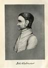
As we began the tour at a significant Quaker location – Burlington City, where the first Burlington County Quakers arrived from England - it is fitting to conclude the tour at the Memorial to the most famous American Quaker of all time: John Woolman (1721-1772), a native of our own Burlington County. Located at 99 Branch Street, this Memorial is dedicated to the memory of the man who represented the values of Quakerism and who actively engaged the community in the good works that stem from these values.
The End
Tour Created by Joseph M. Laufer
Burlington County Historian
Revised with specific directions: 1 - 1- 08 |